JPG
Imagery from VIIRS captured the path of the 2017 total solar eclipse over the contiguous U.S. from the Pacific to the Atlantic for the first time in almost 100 years.

PNG
Visualization of auroras over the Arctic was made using imagery captured by the day/night bands of the Visible Infrared Imaging Radiometer Suite (VIIRS) instrument aboard NOAA-21, during November 5-6, 2023.

JPEG
April 10, 2022 – VIIRS Day Night Band view of the Aurora Borealis from the VIIRS Imagery Viewer.

JPEG
This VIIRS thermal infrared image shows stunning detail of the powerful 'bomb cyclone' that struck the East Coast of North America on Jan. 2-3, 2018.

JPG
The full moon illuminates Day Night Band swaths but “blackouts” occur when Earth’s shadow blocks moonlight during Atlantic Ocean and South America overpasses for the May 16th total lunar eclipse in 2022.

PNG
In this VIIRS RGB image, the lighter blue colors identify sea spray generated by high winds over water in the narrow channels of southeast Alaska. The orientation of the spray also provides a good indication of where the strongest winds are…

JPEG
The VIIRS SnowCloud Discriminator with snow/ice in lavender-tinted white and low stratocumulus low clouds in yellow . The stratocumulus form in streets as strong northerly low level winds bring cold arctic air southward off the ice pack and across…

JPG
VIIRS image from NOAA-20 showing the water temperature of the lakes, taken at 4:19 pm ET on July 21, 2022. Note the cooler water in Lake Superior (blue/purple) compared to the relatively warmer water of Lake Erie (yellow/orange).

JPEG
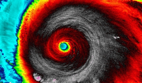
The eye of hurricane Patricia on 10/23/2015.

JPG
VIIRS infrared view of cloud-top gravity waves associated with the Hunga-Tona volcano eruption on January 15, 2022.
