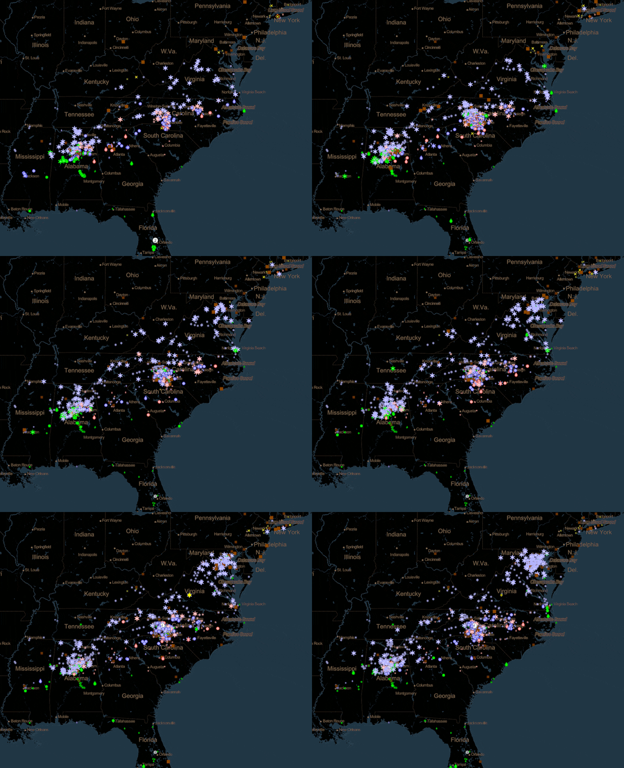
Screenshot from SOSxMobile App. This app allows you different layers that tell you about elements and environments all over the globe over any period of time.
Check out this list of NOAA-based resources that talk about data, the environment, and satellite imagery.
With recent events, teaching students Science, Technology, Engineering and Mathematics (STEM) disciplines has become even more of a challenge--especially for the children and young adults who need it most. Here is a list of NOAA’s mobile-friendly STEM educational resources that will help fill the gap, especially for students in need of higher-level resources in chemistry, environmental science, and technology. Sources include but are not limited to the Ocean Service, JPSS, Office of Education, and Marine Sanctuaries. The list has been roughly ordered from greatest to least mobile usability.
1. Science on a Sphere Explorer
Mobile app that is best suited for tablets, iPhones 7 and above , or newer Android devices. Possibly NOAA’s best mobile offering to date, suitable fo rall ages. The resources found on this app are visualizations made by scientists at NOAA, NASA, and academic institutions from environmental satellites and computer models. There are 120 datasets available for the app so far, including narrated movies. Students of all ages can analyze the data with built-in tools and dig into other included resources.
2. mPING App
Mobile app that is suitable for any type of iPhone, Android, or tablet. Best understood by middle to high school level students. Weather satellites see a lot from above, but can’t always see what’s on the ground. The app, made in partnership with the University of Oklahoma, is called “mPING,” short for Meteorological Phenomena Identification Near the Ground. With the mPING app, students can be citizen scientists by helping NOAA’s National Severe Storms Laboratory collect public weather reports. NOAA’s National Weather Service then uses this information to fine-tune its forecasts and develop new technologies and techniques.

mPING app in action on a mobile device. The different lights signify where the app is currently receiving information from users. For example, some symbols are snow crystals to denote snowfall; others are raindrops to signify rain.
3. CAMEO Chemicals
A mobile-friendly site and app that is available for Android , iPhone and tablet devices. Best formiddle school to college level studentsthat study chemistry. It’s a database with thousands of chemical substances that emergency responders and planners can use to get response recommendations and predict hazards (such as explosions or toxic fumes). Students can search by element or compound name, Chemical Abstracts Service (CAS) number or United Nations/North American (UN/NA) number to find chemicals' information, such as appearance, molecular weight, or boiling points.
4. CrowdMag
Mobile app that is available in iOS and Android. Best forhigh school level and above. The CrowdMag project explores how the digital magnetometers inside modern mobile smartphones can be used as scientific instruments.Also, it’s aimed at building a community of citizen scientists and enthusiasts collecting magnetic field data to further our evolving understanding of the Earth’s magnetic field.With the mobile apps, phones all around the world can send magnetometer data to NOAA’s research group. Whenever students go out for a walk, run, or other outdoor activities, they can use CrowdMag to measure the magnetic data along their way and save the data. Over time, they can create a complete magnetic field map of wherever they live.
5. Rescue 406
Mobile app for Apple iPhone SE and older only. Great for younger students (K-6 grade). Rescue 406 replicates NOAA’s famous SARSAT system to have kids rescue a castaway at sea! Satellites orbiting high above Earth receive the signal from emergency beacons and relay the person’s location to search and rescue crews on the ground. Using the information from these satellites, the student must direct the rescue effort.

Screenshot of Rescue 406 game. In this screen, users need to balance the helicoptor so that its net can land over the person on the ground safely.
6. Digital Coast
Digital Coast is a mobile-optimized website; it’s best viewed in landscape mode. Suitable forall ages. This website is focused on helping communities address coastal issues and visualizing coasts and adjacent land. Pick from informative sections such as the Sea Level Rise Viewer, the Data Access Viewer, Intro to Lidar, Historical Hurricane Tracks, or Flood Exposure Mapper.
7. GOES-R 3D Model
Mobile-friendly website. Good forall ages, especially for the hardcore weather nerds! Explore a GOES-R series satellite in this 3D model, which allows you to move the satellite around and discover all its working parts on a mobile device screen.

Screenshot of GOES-R model on website.
8. Data in the Classroom
Mobile-friendly site that is best viewed on tablet or iPad. Suitable formiddle school to high school ages. Students use real-time ocean data to explore today’s most pressing environmental issues and develop problem-solving skills employed by scientists. Access mobile-friendly curriculum activities about coral bleaching, El Niño, sea level, water quality, and ocean acidification with quizzes, animations, and datasets with a scaled approach to learning and easy-to-use data exploration tools.
9. Phenomenon-Based Learning
Mobile-friendly website, best viewed on iPad or tablet. Lesson plans are available for all primary and secondary grade levels, but most suitable formiddle to high school ages.Meant to be paired with the Science on a Sphere app, this gallery uses cool images, or "phenomena," which will hook students into the lesson. Ideally, phenomena should be visually interesting and not easily understood at first glance. With the help of this resource, complex ideas are visualized in a way that will get students to ask questions and draw upon multiple areas of science to help answer them.

Phenomenon-Based Learning Modules with sample lessons on environments and animals around the world.
10. Virtual Dives
In April 2020, Marine Sanctuaries released a virtual dive page (mobile-friendly) where students ofall agescan hang out with all different types of animals- they can take an up-close look at fish, flora, and the environment around them. To use, students should pair their phones with a virtual reality headset such as VeeR or Google Cardboard.
11. RealEarth™ Satellite App Suite by University of Wisconsin
One of our cooperative institute partners, SSEC at University of Wisconsin, has created a suite of four iPhone and Android apps that can show the live feed of the GOES and POES satellites in NESDIS' fleet. Best understood bymiddle and high school level students. The flagship RealEarth™ app provides access to all of our real-time imagery and weather data, including global and regional atmospheric, short-range forecasts, and terrestrial/oceanographic imagery.WxApp, the simplest app, shows current weather conditions in any given location, along with advanced touch capabilities that allow students to pan,zoom in/out, or animate current weather conditions.With the GOES app, students can see imagery from geostationary satellites GOES East and GOES West; with the ISEE (Innovative Satellite Enhancement Exploration)/JPSS app, imagery from the polar-orbiting satellite fleet is available to view, download, and share on social media.
As more resources become available, this list will be updated and expanded. If you or a student know of any other STEM games and widgets that will work well on mobile devices, please contact us through our social media channels on Instagram , Facebook , or Twitter.
